
 How to resolve AdBlock issue?
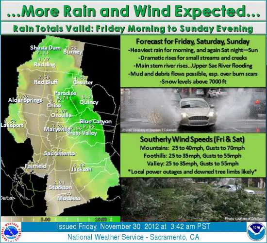
LAKE COUNTY, Calif. – The last large storm of the recent three-storm series is forecast to impact Lake County and much of Northern California on Saturday, bringing with it the most rain and highest winds of the storm trio.
The second storm that moved through on Thursday dumped more 1 inch of rain throughout Lake County, with some areas recording nearly four inches according to Western Weather Group stations while the National Weather Service in Sacramento reports that some high-elevation areas around the county received up to 10 inches of rain.
The National Weather Service in Sacramento reported on Friday afternoon that the strongest storm – with the most rains and highest winds – will reach Lake County Saturday evening.
Weather will remain unstable during the day Saturday with showers, some heavy at times, as the storm front approaches.
As the storm arrives in the evening bringing heavy rains, creeks and streams will quickly rise and urban localized flooding is predicted.
Mud and debris flows, particularly in burn areas, are anticipated, and caution is urged while driving.
With this storm, Lake County is forecast to receive an additional 4 to 8 inches of rain and 25 to 35 mile-per-hour southerly winds, with gusts up to 50 miles per hour.
Due to the saturated grounds combined with the high winds expected with this storm, power outages are expected in local areas.
Temperatures are forecast to remain mild and in the 50s until the storm moves through on Sunday evening.
Residents are urged to use caution when driving and to stay safe this weekend.
Email Terre Logsdon at This email address is being protected from spambots. You need JavaScript enabled to view it. . Follow Lake County News on Twitter, @LakeCoNews.


