
 How to resolve AdBlock issue?
 How do I get information about the water level of the lake? Is the lake at the lowest that it has ever been? How low will the lake get this year and what is predicted for rain this winter?
Thanks!
From “Learning about Lake Levels!” Lorne
Dear Lorne,
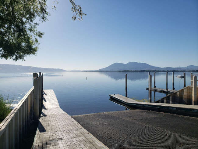
This is a great set of questions Lorne! Also, you are not the only one who has asked about lake levels. Clear Lake’s water level is very low right now, exposing large areas of shoreline and sediment, some that have not been this dry and exposed for decades!
During the drought this year, the low lake level is a concern for many who live on the lake and see the declining edge of the water. Regardless if you are a fisherperson, a shoreline property owner or renter, or enjoy recreation like wake surfing or kayaking, less water in the lake is of extreme interest to many. Being aware of the lake level is fairly easy to do.
Measuring lake levels
Daily lake level data is measured from an in-lake gauge (#11450000) operated and maintained by the United States Geological Survey (USGS).
The gauge has historically been located on a pier at Lake County Vector Control District in Lakeport, but due to the recent drought conditions and lack of water depth at the gauge’s normal location, the gauge was temporarily moved to the Fifth Street ramp at Library Park in Lakeport.
The move caused a few swings of up and down lake level readings during the week around Oct. 7, but as of Oct. 15, the measurements have stabilized. However, the USGS maintains that all online data is provisional until verified and confirmed and usually that can take several months.
Note: The vernacular use of “gage” and “gauge” can be used interchangeably and both can be used as a verb or a noun. The USGS has a historical affinity for the use of “gauge” and according to Merriam-Webster Dictionary, considering global use, “gauge” is the preferred variant of this word and is used more commonly then “gage.” If you ask the Lady of the Lake, life is too short to gage your success by the amount and type of gauges being counted, but don’t mind me and pick the gauge/gage that is right for you!
Gauge relocation and replacement is not a new thing, in fact it has happened many times over the history of USGS monitoring Clear Lake water levels.
For example, prior to 1984, the gauge was located on the public pier on third street in Lakeport, then moved to a private pier a few blocks south. The gauge at that time was non-recording, meaning it didn’t log data, someone had to go out and write down the measurement in a log book. Now the gage measures, stores, and transmits data to USGS satellite and the data quickly makes its way to the gage website.
Then in 1984, the gage was moved to its current permanent home at Lake County Vector Control District on Esplanade in Lakeport. Throughout the years the gage has been adjusted, replaced, repaired and upgraded, and some years during extreme droughts or floods it’s temporarily relocated for better access or to ensure more accurate measurements.
It makes sense that Vector Control would be good partners for a lake gage as low and high water levels influence habitat availability for mosquitos. Also, believe it or not, before the internet, folks would call into the Vector Control District and ask for the current lake levels; now they are simply a few clicks away on your computer or smartphone!
The lake level data is available online in graph or tabulated format at the USGS Clearlake Lakeport CA station.

If you wanted to know stage height data from other gauges around the state, I suggest you explore the Sierra Nevada River Forecast Network Interactive Map. On this site, you can find different lakes or rivers with real-time gages measuring lake levels, stream height and stream flow.
Also, the Lake County Water Resources Department monitors the daily lake level and can provide that to you by phone 707-263-2344, if you do not have access to the website.
How lake level is determined
Clear Lake is different then every other lake, reservoir or water body out there when it comes to the lake level measurement method.
Clear Lake uses the “Rumsey Gage” unit of measurement. This measurement was established by Captain Rumsey in 1873. The measurement was derived from the natural levels of the lake as determined by the Grisby Riffle, with a range between zero and 7.56 feet Rumsey, which is the natural low and high levels of the lake.
For example, the low level at “zero rumsey” is the point at which water is too low to pass the Riffle and flow down Cache Creek; it’s the “natural low” level of the lake.
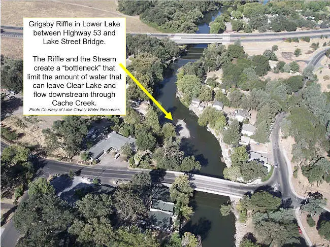
Unlike reservoirs, Clear Lake’s water level is naturally controlled by the Grigsby Riffle. The Grigsby Riffle is a naturally formed rock gravel formation at the confluence of Cache Creek and Seigler Creek; this spot can be easily observed from the Lake Street Bridge in Lower Lake.
The combination of elevation, gravel accumulation and creek bed constriction physically limits the maximum amount of water that can pass through from the lakeside downstream to the rest of Cache Creek.
There is a court-ordered “Bemmerly Decree” (1940) that prohibits the excavation or alteration of the Riffle, meaning that no one is allowed to build up or tear down the riffle which maintains the water level in Clear Lake from leaving “too fast” down Cache Creek.
You may notice this phenomenon during flood years, where even though the Cache Creek dam (located 3 miles downstream Cache Creek) is fully open, the amount of water flowing through is the same. The gravel impoundment, stream shape and stream bottom elevation of the Grisby Riffle is literally controlling the amount of water that can leave and flow out of the lake. This is the bottleneck point.
Many think the Cache Creek dam, managed by Yolo County, is open all the time and allowing “all the water to flow from the lake”; but in fact most of this current drought year Cache Creek above and around the Grisby Riffle has been dry — for months water has not been flowing out of Clear Lake down through Cache Creek.
There is a base flow of water that does flow downstream from Cache Creek to Yolo County, but the amounts of Clear Lake water allowed to be actively “taken” from the lake to Yolo are regulated naturally and legally.
The other court-ordered decrees, the Gopcevic (1920) and the Solano (1978, revised in 1995), limit the amount and timing of water to be released by the Cache Creek Dam. This year, Yolo County was not able to use any of the water in Clear Lake as the lake level was too low to “share” as declared by these decrees. This is important to note because the water level we see today in Clear Lake would be the same regardless if there was a regulated dam downstream or not.
The history of the Decrees and story about how Yolo County gained water rights of Clear Lake is fascinating (albeit a bit frustrating) and I recommend anyone interested to grab a cup of tea, a quiet window seat, and dedicate some time to read the information provided online by the County of Lake Water Resources including “The History of Clear Lake” and “How Yolo Obtained Water Rights.”
What about next year's rain outlook and impacts on lake level?
As for the lake levels next year, we still don’t know how much rain we will get this next wet season or if that rain will be sufficient to saturate the ground within the watershed and accumulate into enough runoff to replenish Clear Lake.
Some climate predictions by NOAA’s National Weather Service and the International Research Institute for Climate and Society have indicated that we are going into La Niña oscillation with high probability (87%).
La Niña winters are known for cooler than normal ocean conditions, which usually mean southern areas of the country tend to stay drier and warmer than normal and northern parts of the country are cooler and wetter than average. Northern California is located somewhere in the middle of these patterns, but it’s a good guess that this year’s La Niña might prolong drought conditions one more year.
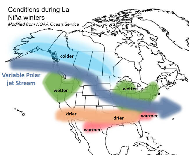
While not directly related to lakes, the Lady of The Lake loves to learn about ocean patterns and impacts on inland waters. NOAA’s National Ocean Service makes connections between La Niña / El Niño climate patterns that have direct impacts on natural occurrences and disasters on the mainland, like floods and wildfires.
While probability is high that La Niña will characterize the type of winter and wet season that will occur across the Pacific states this coming winter, the most accurate predictions will come to fruition in November. And until then, we shall remain hopeful and gauge that daily lake level gage data.
Sincerely,
Lady of the Lake
The Lady of the Lake would like to acknowledge and thank Dr. Jamie Scott at Lake County Vector Control District and D. McGee at USGS for their help in contributing valuable information to this article.
Angela De Palma-Dow is a limnologist (limnology = study of fresh inland waters) who lives and works in Lake County. Born in Northern California, she has a Master of Science from Michigan State University. She is a Certified Lake Manager from the North American Lake Management Society, or NALMS, and she is the current president/chair of the California chapter of the Society for Freshwater Science. She can be reached at This email address is being protected from spambots. You need JavaScript enabled to view it..


