LAKE COUNTY, Calif. — Over the course of the weekend, Lake County saw several inches of rainfall as an atmospheric river passed over Northern California.
AccuWeather Chief Meteorologist Jon Porter said the rainfall came about a month ahead of average.
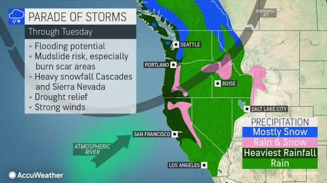
The region badly needs the water due to the ongoing drought. As well, California has been hard-hit by another wildfire season.
“Repeated storms delivering such copious rainfall will have a major effect on the wildfire season — effectively ending the wildfire season from Northern California northward,” Porter said.
The storms also are forecast to bring heavy snowfall to the Cascades and Sierras.
There was steady rainfall from Saturday night into Sunday afternoon before the precipitation started to ease.
The National Weather Service’s observation stations in Lake County reported that, for the 36-hour period ending 2 a.m. Monday, there were rainfall totals around the county ranging from 4.29 inches near Upper Lake, 4.43 inches in Kelseyville, to 5.41 inches in Lyons Valley, 6.09 inches in Lower Lake, 6.75 inches near Lake Pillsbury, 7.69 inches at Bartlett Springs, 8.73 inches at Hidden Valley Lake, 9.23 inches in Middletown and 9.52 inches in Whispering Pines.
While Porter said the parade of storms that has brought the heavy rainfall to Lake County and Northern California “will have a positive impact on the water table,” he added, it “won’t be enough to solve all of the water problems which have been compounding for many years.”
Along with the heavy rainfall came numerous reports from Saturday night through Sunday of downed trees, downed lines, boulders in roadways and mudslides.
A mudslide on Sunday afternoon closed Highway 20 in both directions at Highway 16, with another slide later reported near Island Drive in Clearlake Oaks.
The National Weather Service said lighter rainfall would continue in Lake County into Monday and Tuesday, with nearly another inch of rainfall possible in that time
The unsettled weather is the tail end of a strong upper low pressure system winding down into British Columbia through Monday, the National Weather Service reported.
Conditions are expected to clear beginning on Wednesday and continuing until later in the week, according to the forecast.
Temperatures will increase toward the end of the week from the mid 50s to the high 70s in some parts of Lake County, the forecast said.
Email Elizabeth Larson at This email address is being protected from spambots. You need JavaScript enabled to view it.. Follow her on Twitter, @ERLarson, or Lake County News, @LakeCoNews.